
Chapter 9: Review of efforts made by Member States to implement the Sendai Framework
Introduction
The Sendai Framework represents a risk-informed approach to sustainable development and is closely associated with specific demands regarding data collection and analysis. Renewed commitments and demand for robust and evidence-based guidance on DRM require the transformation of behaviour and practice in multiple dimensions. These include data, policy, planning protocols, collaboration mechanisms for effective decision-making, and technical and functional implementation capacities. The data requirements to meet these goals require coordination among relevant stakeholders, which has traditionally not been a reality.
The Sendai Framework Data Readiness Review, with contributions from 87 countries, assessed countries-readiness to monitor and report, in addition to the availability of national disaster-related data and requisite gaps in terms of financial resources and technical expertise. Within the group of countries participating in the review, a quarter reported no or only preliminary progress on national and local DRR strategies and plans aligning with the Sendai Framework (Target E), 72% reported medium to substantive progress on alignment and 3% reported full implementation. The review concluded that effective reporting of progress towards the global targets of SDGs and the Sendai Framework would require the use of multiple types of data, including EO and geospatial information. Advances in national reporting and data-collection practices offer useful standards, tools and approaches to guide countries efforts in bridging the gap between where they are today and where they need to be to support the goals of the Sendai Framework.
9.1 Disaster loss databases
The Sendai Framework and its predecessor, HFA, have explicitly recognized the importance and usefulness of collecting loss data as one of the actions that will help countries to increase knowledge about the risks they face. In addition to the loss data for Targets A-D outlined in the previous chapter, Sendai Framework Priority 1, Understanding disaster risk (para. 24), suggests that Member States:
- (d) Systematically evaluate, record, share and publicly account for disaster losses and understand the economic, social, health, education, environmental and cultural heritage impacts, as appropriate, in the context of event-specific hazard-exposure and vulnerability information;
- (e) Make non-sensitive hazard exposure, vulnerability, risk, disaster and loss-disaggregated information freely available and accessible, as appropriate;
The text of the Sendai Framework (para. 15) states:
There are several consequences of the wider scope of the Sendai Framework. The explicit recommendations of Priority 1 on loss data collection, and that the global indicators for Targets A-D;require loss data, mean that countries are strongly encouraged to account systematically for disaster losses and damage for a wide spectrum of disaster scales and a broader set of hazards. For over a decade, UNISDR has been working with Member States to promote disaster loss accounting. Systematically accounting for losses translates, in technological terms, into the creation of national disaster loss databases that can record many loss indicators for disasters, at all scales, in a disaggregated manner. Priority 1 recommendations go even further, suggesting these databases and information should be publicly accessible.
While there are some reputable global disaster loss databases such as EM-DAT, NatCat from Munich Re, Sigma from Swiss Re and others, it is important to note that any reporting process to the Sendai Framework Monitoring system has to be based on officially endorsed data, collected and validated by national governments. This data should comply with the requirements of the Sendai Framework. It should address small- and large-scale disasters, and slow- and rapid-onset events, cover a large number of hazards (including technological and man-made hazards) and, most importantly, record data for a set of global indicators, some of which were not available in the global loss databases.
Furthermore, for effective implementation of the recommendations of the Sendai Framework, databases should be built gathering geographically disaggregated data that has to be usable at a subnational scale. As a minimum, data in the disaster loss databases should be disaggregated by event, hazard and geographic area. Aligning loss databases with the SDG principles, countries are encouraged to pursue even higher levels of disaggregation (by recording differences in socioeconomic impacts based on sex and gender roles, household level, etc.). People experience disasters differently, even within the same household. Traditional measures are not able to capture these variations because metrics stop at the national, subnational or even household level. While data remains sparse, there is evidence that women and children are disproportionally affected by disasters in some -but not all- countries. Therefore, more surveys are needed to capture the underlying risks that can include, but go beyond, gender and age divides and inform policies on such disparities.
9.2 Successes and challenges in establishing national monitoring capabilities
9.2.1 Expectations of Member States for monitoring Sendai Framework implementation
To understand the successes and challenges of Sendai Framework monitoring, it is important to put into perspective what Member States are expected to do, in terms of establishing the institutional mechanisms that are required to undertake reporting as well as substantive information to be collected and shared through the system. Though the Sendai Framework Monitoring system has many functions that are common to a standard reporting mechanism related to any area of international development, it also has certain distinctive points owing to the cross-sectoral nature of DRR.
The first steps to be undertaken in the Sendai Framework monitoring process are to nominate a focal point for Sendai Framework monitoring, select institutions involved in the monitoring process, and define the roles and responsibilities of the selected institutions.
Every Member State is expected to nominate a main focal point for monitoring its implementation of the Sendai Framework and formally inform UNISDR. The focal point then has to undertake a selection of national institutions that will be engaged in the monitoring process. This enhances a decentralized and systematized process of monitoring through data sharing among various ministries and departments. It is also possible for the designated focal point to bring in institutions outside its jurisdiction, if deemed necessary for the monitoring progress.
9.2.2 Successes in establishing national capabilities for monitoring Sendai Framework implementation
This section presents the successes that have emerged since the launch of the Sendai Framework Monitoring on 1 March 2018, regarding the scale of reporting, engagement of NSOs, capacity-development efforts, and cross-sectoral, multi-stakeholder partnerships in data collection and monitoring procedures.
9.2.3 Challenges in establishing national capabilities
This section identifies the challenges that Member States are experiencing in reporting against the indicators of the seven global targets of the Sendai Framework. Challenges relate to data management through sequential phases of collection, validation, storage and analysis, proposed baselines for analysis, as well as overall institutional capacities in monitoring and reporting as they emerge from different country experiences.
Data is at the core of the monitoring process. The United Nations Secretary-General's Independent Expert Advisory Group (IEAG) on the data revolution has suggested nine core principles that should be common to all actors contributing data to the measurement of sustainable development.
9.2.4 Reporting by targets: trying to be on target
There are several target-specific challenges that Member States may be facing while reporting against the indicators of each of the global targets. This requires further technical discussion on those issues that have been highlighted in the technical guidance for monitoring and reporting on progress in achieving the global targets of the Sendai Framework. One of the main considerations OEIWG made in its report was that Member States agreed that countries may choose to use a national methodology or other methods of measurement and calculation to measure the key parameters of individual targets, especially for Targets A-D. However, OEIWG also recommended that countries keep the metadata consistent if the methodology is changed.
9.3 Support for thematic and sectoral review of progress
Sectoral analysis is required for full reporting under the Sendai Framework. There has already been considerable international cooperation in various sectors. Two examples are given below of such cooperation, relating to agriculture and school safety.
9.3.1 Agriculture sector
Agriculture forms the livelihoods of 2.5 billion people worldwide. Three quarters of the world's poor obtain their food and income from farming, livestock rearing, forestry or fishing. Smallholders manage over 80% of the world's estimated 500 million small farms and provide over 80% of the food consumed across the developing world. With the growing frequency and impact of disasters and extreme events, they regularly face storms, drought, floods, pests and diseases that destroy or damage harvests, livestock, supplies, equipment, seeds and food. Over the past decade, 26% of all damage and loss from climate-related disasters in developing countries was in the agriculture sector. Moreover, the impact of disasters is not limited to the immediate short term. Disaster often undermine decennial development gains, thus making communities increasingly vulnerable and less able to absorb, recover and adapt to future risks.
In partnership with UNISDR, FAO has developed the Methodology to Assess Direct Loss from Disasters in Agriculture, which is used to track progress towards achieving Indicator C-2 on reducing direct agricultural loss attributed to disasters, under Sendai Framework Target C on global economic loss. This new methodology seeks to standardize disaster impact assessment in agriculture. However, it needs to be institutionalized at the country level. FAO has therefore been providing support and building capacity of national institutions for the adoption, operationalization and implementation of this methodology. A growing number of countries across Latin America, the Caribbean, East Africa and Southeast Asia are already adopting this new approach and are becoming ready to report and track their progress towards Sendai Framework commitments to reduce direct loss from disasters in agriculture.
FAO supports countries in reducing risk and strengthening agricultural livelihoods for building resilience to disasters and crises, while remaining context specific and anchored in local livelihoods and food systems. FAO resilience-relevant work is defined around three main groups of shocks: natural hazards, including climate change extreme events; food chain crises and transboundary threats, including pests and diseases and food safety, in alignment with the Sendai Framework broader scope of hazards; and protracted crises, including violent conflicts. Through this holistic approach, FAO is able to address the compound nature of disasters and the interconnectedness of threats.
Improving crisis and risk governance
Agricultural livelihoods can be protected from multi-hazards only if adequate disaster risk and crisis governance is present at all levels through risk-informed legal, policy and institutional systems, as well as disaster and risk management capacities for the food and agriculture-related sectors.
Early warning - early action
Monitoring risk and disasters helps to prevent, prepare and reduce impact. The FAO Early Warning Early Action (EWEA) system translates warnings into anticipatory actions to reduce the impact of specific disaster events. It focuses on consolidating available forecasting information and putting plans in place to ensure government partners act when a warning is at hand. On a global level, early warning sources to monitor the main risks to agriculture and food security are published in the EWEA quarterly report. At a country level, FAO works closely with country offices to develop EWEA systems tailored to local contexts. Implementation is under way in Kenya, Madagascar, Mongolia, Pacific Islands, Paraguay, Sudan and others.
9.3.2 School safety initiatives
The Global Alliance for Disaster Risk Reduction and Resilience in the Education Sector is a multi-stakeholder mechanism composed of United Nations agencies, international organizations and regional networks. Partners are working to ensure that all schools are safe from disaster risks and all learners live in a culture of safety. The work of the Global Alliance is expected ultimately to contribute to a global culture of safety and resilience through education and knowledge, in support of SDGs and in line with the Sendai Framework. It promotes a comprehensive approach to DRR education through the Comprehensive School Safety Framework. This is based on education policies, plans and programmes that are aligned with disaster management at regional, national, subnational, district and local school site levels, whose goals are to: (a) protect students and educators from death, injury and harm in schools, (b) plan for continuity of education through all expected hazards and threats, (c) safeguard education sector investments and (d) strengthen risk reduction and resilience through education.
The Worldwide Initiative for Safe Schools was launched in 2013 by UNISDR in collaboration with partners from the Global Alliance on Disaster Risk Reduction Education and Resilience in the Education Sector as a response to the High-Level Dialogue Communiqué at the 2013 Global Platform for Disaster Risk Reduction. This initiative aims at securing political commitment and fostering the implementation of safe schools globally. The Worldwide Initiative motivates and supports governments to develop and implement national school safety policies, plans and programmes in combination with the three technical aspects of comprehensive school safety. It offers technical assistance and expertise to support interested governments in implementing comprehensive school safety at the national level and promotes good practices and achievements in safe school implementation for replication in other countries and regions.
Partners of the Global Alliance developed different tools and methodology to enhance school safety. For example, the United Nations Educational, Scientific and Cultural Organization (UNESCO) promotes a multi-hazard school safety assessment methodology, namely visual inspection for defining safety upgrading strategies (VISUS). The VISUS methodology has a strong component on capacity-building for decision makers, technical staff and universities. It allows them to make better informed decisions on how to prioritize funding for improved school safety and has been successfully tested in seven countries (El Salvador, Haiti, Indonesia, Italy, Lao People's Democratic Republic, Mozambique and Peru), where the security of more than 500,000 students and educational staff was assessed. UNESCO is working on the conceptualization of an International Programme for Safe School Assessment, through the implementation of the VISUS methodology worldwide.
9.4 Development of national disaster-related statistics
The adoption of common reporting mechanisms for the Sendai Framework and the 2030 Agenda has prompted the international statistical community to support the development of disaster-related statistics and frameworks. The following section examines this work and its repercussions.
Within the context of a globally agreed policy framework and global indicator monitoring systems, governments have given increased attention to disaster-related statistics. As this area of statistics is a new endeavour in nearly all countries, there is a strong demand for technical guidance and sharing of tools and good practices internationally.
Core concepts and indicators for DRR for international monitoring are defined in the Sendai Framework and SDGs, but there is a need to translate the agreed concepts and definitions into specific instructions and technical recommendations for production and dissemination of statistics. Basic requirements for the international indicator monitoring systems include comparability of concepts and methods for measurement across disaster occurrences. These systems depend heavily on coordination and consistency at the national and local levels.
Countries have different practices for compiling data and preparing statistical tables related to disasters, which makes it difficult to make comparisons or conduct time-series analyses covering multiple disasters. The Sendai Framework focuses on risk assessments, mirroring government demands for improving prevention and preparedness efforts. As risk assessments require information beyond operational disaster data, there is a need for disaster measurements and statistics across disasters, times and geographic locations, and for the integration of disaster information with social, economic and environment statistics.
In many cases, disaster-related data is produced outside the national statistical system and is not included in official statistics. NSOs are often not involved in compiling the data. However, considering the traditional strengths of NSOs and the institutional context for national DRM, different roles can be identified for NSOs. These roles can be grouped into two parts:
- Core roles that should be undertaken by any NSO. These reflect typical strengths of NSOs, such as producing time-series statistics and indicators, providing baseline information fit for purpose for DRM, supporting the assessment of social, environmental and economic impacts, etc.
- Expanded roles with additional tasks that could be incorporated into the functions and responsibilities of NSOs. These can include leading impact assessments, coordinating geographic information services and conducting risk assessments. Some NSOs have already implemented such roles
9.5 Conclusions
Four years after the adoption of the 2030 Agenda and the Sendai Framework, countries have taken bold steps towards meeting the ambitious aspirations of these transformative plans. In their shared quest to achieve the goals, countries are dealing with daunting global challenges: inequality, a changing climate, instability and fast-paced urbanization. Decision makers across the globe need to critically reflect on how their countries, cities and communities can become more resilient while confronting the interrelated risks. These normative aspirations must be matched with implementation and tangible progress by providing the most up-to-date data and achievements so far. More solid evidence is required, but preliminary findings reiterate previous trends on the highest toll of disasters experienced in the most vulnerable segment of the world's populations.
Special case study
Developing urban and community disaster risk reduction plans using collaborative mapping techniques - Dar es Salaam, United Republic of Tanzania
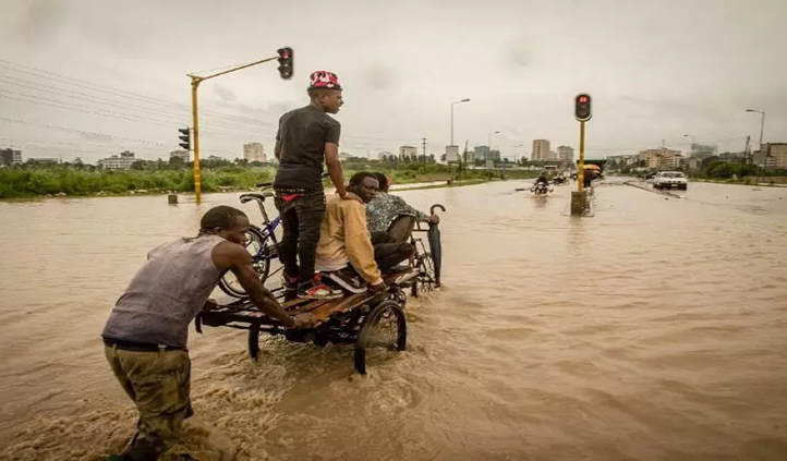
Dar es Salaam, United Republic of Tanzania, is one of the fastest growing cities in Africa. With a current population of 4.1 million, it is projected to become a megacity by 2030. Maps and geospatial information are critical to the development of any city, vital for placing public services and ensuring the safety of its citizens. However, numerous factors add complexity to the security of Dar es Salaam's residents.
These include the rapid population growth from a population of roughly 300,000 in 1970 to that of the present day, unplanned and informal settlement, and a highly variable climatic environment, all of which contribute to a high risk of flooding. Dar es Salaam's institutions have limited technical capacity in terms of skills, training and equipment. This challenge is further compounded by lack of access to existing geospatial information and gaps in data.
In early 2018, heavy rains caused widespread flooding that affected 50,000 people and claimed at least 41 lives. According to official figures, the emergency response and recovery cost to the Government was more than $780,000.
In response to this rising set of challenges, a consortium of local academic institutions and NGOs working with the Tanzanian Commission of Science and Technology, the Tanzania Red Cross Society, the World Bank and community members formed Ramani Huria in 2015. This is a community risk mapping project in Dar es Salaam that is generating substantial amounts of geospatial information. Such information includes landuse, infrastructure and exposure data that directly informs the development of DRM and DRR plans. As of October 2018, Ramani Huria has mapped neighbourhoods covering roughly 3.5 million residents in over 228 communities.
The collaborative process informs decision-making at various levels within the city to take actions that can ameliorate urban conditions for the residents of Dar es Salaam. At a community level, the maps are used to inform actions related to drain cleaning programmes and evacuation planning, supporting the establishment of 10 emergency flood response teams, in collaboration with the Tanzania Red Cross Society programme Zuia Mafuriko (Swahili for "Stop Flooding"). At the city level, the mass of geospatial information supports the development of an ex ante plan for emergency declaration, actions, and definitions of roles and responsibilities in the event of a disaster. This is done through the Dar es Salaam Multi-Agency Emergency Response Team, a city-wide, multistakeholder initiative that coordinates city- and regional-level response and planning for disasters. Maps are created through a collaborative process that combines students and community members.
This enables technological skills that generate geospatial information to be transferred, historical flood extents to be established, and the community to participate and be informed with respect to disaster plans as a single process. In increasing the capacity for generating and consuming geospatial information, city- and community-level resilience to disasters is strengthened.
Furthermore, the collaborative approach acts as a mechanism to engage and inform community members and local government to simultaneously change behaviour and support community action. For example, the combination of informing community members on the impact of solid waste being dumped into drains and the provision of locally accessibly solid waste processing sites facilitates a reduction in the severity of flooding. At the broader city level, this allows for a streamlined focus on the larger underlying issues and causes of risk.